Moosehorn National Wildlife Refuge – Washington County, Maine

Moosehorn National Wildlife Refuge is one of the northernmost National Wildlife Refuges in the Atlantic Flyway, a migratory route that follows the eastern coast of North America. The refuge provides important feeding and nesting habitat for many bird species, including waterfowl, wading birds, shorebirds, upland game birds, songbirds, and birds of prey. The refuge consists of two divisions. The Baring Division covers 20,016 acres and is located off U.S. Route 1, southwest of Calais, Maine. The 8,735-acre Edmunds Division is between Dennysville and Whiting on U.S. Route 1 and borders the tidal waters of Cobscook Bay. Each division contains a National Wilderness Area, thousands of acres managed to preserve their wild character for future generation. The East Coast Greenway, connecting Calais, Maine to Key West, Florida, runs through part of the refuge.
Edmunds Division

New photo by Wanderlust Family Adventure / Google Photos

Baring Division

New photo by Wanderlust Family Adventure / Google Photos

On the edge of the refuge next to US Route 1 are platforms erected for nesting bald eagles.

New photo by Wanderlust Family Adventure / Google Photos

Eagle Hill Bog Trail – Roosevelt Campobello International Park (New Brunswick, Canada)

The Eagle Hill Bog Trail in Roosevelt Campobello International Park on Campobello Island in New Brunswick, Canada is a wonderful short hike through a maritime bog ecosystem. The hike is very easy along a boardwalk through the bog, the highpoint is observing the carnivorous plants that abound here.

New photo by Wanderlust Family Adventure / Google Photos

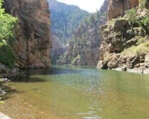
Curecanti National Recreation Area – Gunnison, Colorado

Curecanti National Recreation Area is a National Park Service unit located on the Gunnison River in western Colorado. Established in 1965, Curecanti is responsible for developing and managing recreational facilities on three reservoirs, Blue Mesa Reservoir, Morrow Point Reservoir and Crystal Reservoir, constructed on the upper Gunnison River in the 1960s by the U.S. Bureau of Reclamation to better utilize the vital waters of the Colorado River and its major tributaries. A popular destination for boating and fishing, Curecanti offers visitors two marinas, traditional and group campgrounds, hiking trails, boat launches, and boat-in campsites. The state’s premiere lake trout and Kokanee salmon fisheries, Curecanti is a popular destination for boating and fishing, and is also a popular area for ice-fishing in the winter months.

New photo by Wanderlust Family Adventure / Google Photos

Johnstown Flood National Memorial – South Fork, Pennsylvania

Johnstown Flood National Memorial commemorates the more than 2,200 people who died in the Johnstown Flood on May 31, 1889, caused by a break in the South Fork Dam, an earthen structure. The memorial is located at 733 Lake Road near South Fork, Pennsylvania, about 10 miles northeast of Johnstown. The memorial preserves the remains of the dam and portions of the former Lake Conemaugh bed, along with the farm of Elias Unger and the clubhouse of the South Fork Fishing and Hunting Club which owned the dam and reservoir.

New photo by Wanderlust Family Adventure / Google Photos

Lake Mead National Recreation Area – Boulder City, Nevada

Lake Mead National Recreation Area is a U.S. National Recreation Area located in southeastern Nevada and northwestern Arizona. Lake Mead NRA follows the Colorado River corridor from the westernmost boundary of Grand Canyon National Park to just north of the cities of Laughlin, Nevada and Bullhead City, Arizona. It includes all of the eponymous Lake Mead as well as the smaller Lake Mohave – reservoirs on the river created by Hoover Dam and Davis Dam, respectively – and the surrounding desert terrain and wilderness. Formation of Lake Mead began in 1935, less than a year before Hoover Dam was completed. The area surrounding Lake Mead was established as the Boulder Dam Recreation Area in 1936 and the name was changed to Lake Mead National Recreation Area in 1947. In 1964, the area was expanded to include Lake Mohave and its surrounding area and became the first National Recreation Area to be designated as such by the U.S. Congress.

New photo by Wanderlust Family Adventure / Google Photos

At the marina be sure to walk out onto the docks, not only can you admire the boats but the swarming fish waiting to be fed are a sight to behold.

New photo by Wanderlust Family Adventure / Google Photos

Although boating is the main attraction there are hiking and camping opportunities available.

New photo by Wanderlust Family Adventure / Google Photos