Rainbow Bridge National Monument – Glen Canyon National Recreation Area

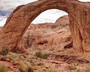
Rainbow Bridge National Monument is administered by Glen Canyon National Recreation Area, Utah. Rainbow Bridge is often described as the world’s highest natural bridge. The span of Rainbow Bridge was reported in 1974 by the Bureau of Reclamation to be 275 feet, but a measurement of span according to definition by the Natural Arch and Bridge Society in 2007 resulted in a value of 234 feet. At the top it is 42 feet thick and 33 feet wide. The bridge, which is of cultural importance to a number of area Native American tribes, has been designated a Traditional Cultural Property by the National Park Service. To get to the bridge prepare for a very long hot hike or take the boat ride to the site.

New photo by Wanderlust Family Adventure / Google Photos

Glen Canyon Dam – Glen Canyon National Recreation Area (Arizona)

Glen Canyon Dam is a concrete arch-gravity dam on the Colorado River in northern Arizona, near the town of Page. The 710 foot high dam was built by the U.S. Bureau of Reclamation from 1956 to 1966 and forms Lake Powell, one of the largest man-made reservoirs in the U.S. The dam is named for Glen Canyon, a series of deep sandstone gorges now flooded by the reservoir; Lake Powell is named for John Wesley Powell, who in 1869 led the first expedition to traverse the Colorado’s Grand Canyon by boat.

New photo by Wanderlust Family Adventure / Google Photos

Monument Valley – Navajo Nation, Arizona

Monument Valley (Navajo:valley of the rocks) is a region of the Colorado Plateau characterized by a cluster of vast sandstone buttes, the largest reaching 1,000 feet above the valley floor. It is located on the Arizona–Utah state line, near the Four Corners area. The valley lies within the territory of the Navajo Nation Reservation and is accessible from U.S. Highway 163. Monument Valley has been featured in many forms of media since the 1930s. Director John Ford used the location for a number of his best-known films.

New photo by Wanderlust Family Adventure / Google Photos

Marble Canyon – Arizona

Marble Canyon is the section of the Colorado River canyon in northern Arizona from Lee’s Ferry to the confluence with the Little Colorado River, which marks the beginning of the Grand Canyon. Marble Canyon marks the western boundary of the Navajo Nation. In 1975, the former Marble Canyon National Monument, which followed the Colorado River northeast from the Grand Canyon to Lee’s Ferry, was made part of Grand Canyon National Park. The name Marble Canyon is a misnomer because there is no marble there. Although John Wesley Powell knew this when he named the canyon, he thought the polished limestone looked like marble. In his words, “The limestone of the canyon is often polished, and makes a beautiful marble. Sometimes the rocks are of many colors – white, gray, pink, and purple, with saffron tints.”

New photo by Wanderlust Family Adventure / Google Photos

Lee’s Ferry – Glen Canyon National Recreation Area (Arizona)

Lee’s Ferry is a common launching point for river runners starting their journey through Marble Canyon and then onward to the Grand Canyon. It is part of the Glen Canyon National Recreation Area. Marble Canyon is also well known for the Navajo Bridge, where US Highway 89A crosses the Colorado River. This is one of the very few areas where you can reach the Colorado River by car. Due to its unique geography – the only place in hundreds of miles from which one can easily access the Colorado River from both sides – it historically served as an important river crossing and starting in the mid-19th century was the site of a ferry operated by John Doyle Lee, for whom it is named. Boat service at Lees Ferry continued for over 60 years before being superseded by a bridge in the early 20th century, which allowed for much more efficient automobile travel.

New photo by Wanderlust Family Adventure / Google Photos